County changes evacuation procedures
By Santa Ynez Valley Star Staff · Tue Mar 17 2020
 By Brooke Holland
Noozhawk
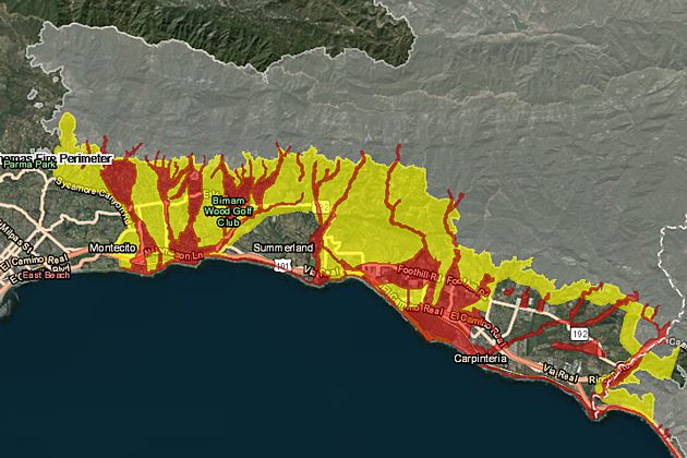
Santa Barbara County authorities have announced changes to the way evacuation orders will be issued and released a new “risk map” for debris flows after the deadly Jan. 9 storm.
The interactive map outlines areas with an extreme risk or high risk of debris flows in the event of rains that reach half an inch per hour or more, which includes communities below burn scars from the recent Thomas, Alamo, Whittier and Sherpa fires.
With rain falling that heavily on those burn scars, a storm would be capable of producing debris flows similar to the Jan. 9 storm.
The new interactive map and other information are available on Santa Barbara County's new website, ReadySBC.org.
At a meeting with reporters at Montecito Fire Station 1, Sheriff Bill Brown explained the new evacuation timeline for storms, which starts when the National Weather Service alerts the county Office of Emergency Management 72 hours before a major storm is forecast to arrive.
The timeline as a heavy storm approaches will be:
By Brooke Holland
Noozhawk
Santa Barbara County authorities have announced changes to the way evacuation orders will be issued and released a new “risk map” for debris flows after the deadly Jan. 9 storm.
The interactive map outlines areas with an extreme risk or high risk of debris flows in the event of rains that reach half an inch per hour or more, which includes communities below burn scars from the recent Thomas, Alamo, Whittier and Sherpa fires.
With rain falling that heavily on those burn scars, a storm would be capable of producing debris flows similar to the Jan. 9 storm.
The new interactive map and other information are available on Santa Barbara County's new website, ReadySBC.org.
At a meeting with reporters at Montecito Fire Station 1, Sheriff Bill Brown explained the new evacuation timeline for storms, which starts when the National Weather Service alerts the county Office of Emergency Management 72 hours before a major storm is forecast to arrive.
The timeline as a heavy storm approaches will be: