
Boundaries along Highway 154, Santa Maria adjusted for final approval
By Giana Magnoli
Noozhawk Managing Editor
Santa Barbara County’s redistricting commission made additional changes to the county supervisorial district map during a meeting Wednesday, Dec. 8, so formal adoption will be pushed to next week.
Commissioners voted 10-1 to change the District 4 and District 5 boundary within the city of Santa Maria, which was proposed by Commissioner Jannet Rios and supported by several members of the Santa Maria community, including Mayor Alice Patino and Councilman Mike Cordero, during public comment.
Rios said the specific area includes some “core institutions” that are the “heart and soul” of the larger District 5.
Commissioners also supported adjusting the District 1 and District 2 boundary near State Route 154 to unify more of the local watershed.
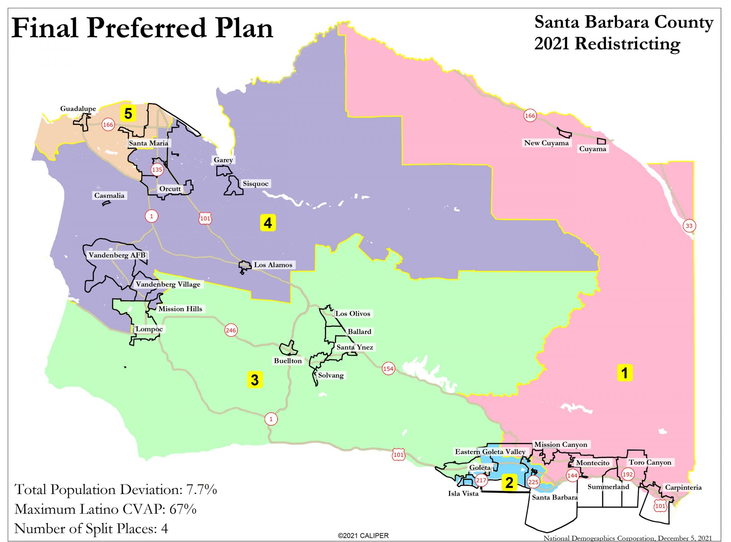
The Santa Barbara County Citizens Independent Redistricting Commission is tasked with creating a district map to elect the five-member Santa Barbara County Board of Supervisors. The new district map will be used for the next 10 years, starting in the 2022 elections.
Commissioners have reviewed map proposals from the public and last week chose three “focus maps.”
The 11 commissioners modified one of the three focus maps to create a final preferred map during a nine-hour meeting on Dec. 4.
They were expected to formally adopt the map on Dec. 8 but instead made some more modifications to district boundaries, so they had to meet again on Monday, Dec. 13, to adopt it. That was just two days before the Dec. 15 deadline to ratify a map, according to commission attorneys.
There was not time for any more changes, so commissioners will have to adopt this map or another map that has been publicly posted.
The Santa Maria-area changes approved Dec. 8 will move that an area in Santa Maria from the Fourth District to the Fifth District. That area lies between Broadway on the west and Highway 101 on the east, and between Main Street and Stowell Avenue.
A portion of northeastern Santa Maria will be moved from the Fifth District to the Fourth District to use Highway 101 as a convenient boundary, commissioners also decided.
The new map for Santa Barbara County districts places Isla Vista with the eastern Goleta Valley and Santa Barbara, and groups Guadalupe with part of Santa Maria, which are two major changes compared to the current map.
The final preferred map from Dec. 4 drew Fifth District Supervisor Steve Lavagnino out of the district he represents. That was not mentioned during Wednesday’s meeting, but with the District 4 and District 5 boundary changes in Santa Maria, his neighborhood was drawn back in.
Fifth District Planning Commissioner Daniel Blough noted earlier Dec. 8 that he and Lavagnino would be residents of the Fourth District in the proposed map boundaries. With the latest changes, it was unclear whether Blough’s residence would be in the future Fourth District or Fifth District.
Any district-based commissioners drawn out of their districts will be able to serve out the remainder of their terms, county counsel staff said in response to Blough’s comments at this week’s Planning Commission meeting.
“Clearly, if it doesn’t change at the end of next year, I’m done, which is probably fine, make my wife happy,” Blough told his fellow commissioners.
The Dec. 8 redistricting meeting agenda included a report on the outreach process and a legal report that analyzed how the final preferred map meets criteria for drawing district maps. The legal report will have to be modified since the final preferred map was changed.
Demographic information for the proposed final district map was not available Dec. 8 because of the modifications during the meeting.
The changes were considered minor, according to commission attorney Andrea Ordin, so it is likely that the demographic information will not have major differences from the final preferred map chosen Dec. 4.
Each district should have a population deviation under 10% from the ideal population (splitting the countywide population five ways, which would be 89,341 people for each district), according to the report.
The citizen voting age population has a larger range between districts, according to the demographic data on Dec. 4 version of the map: 72,497 people in District 2 to 32,249 in District 5. District 1 has more than twice as many registered voters as District 5, for example, and District 2 has more than twice as many citizens of voting age than District 5.
District 5, which includes the city of Guadalupe and the majority of Santa Maria, was drawn as a “Latino opportunity district” to “provide Latino voters the opportunity to elect candidates of their choice in compliance with Section 2 of the Voting Rights Act,” the draft legal report states.
Census data shows 47% of countywide residents are Hispanic/Latino and 83% of District 5 residents are Hispanic/Latino.
Scroll down for each district’s demographic information based on 2020 U.S. Census information and 2015-2019 American Community Survey information.
Each district is geographically contiguous except for the Channel Islands, which are placed in District 2 and are not accessible through regular ferry service embarking from Santa Barbara County, the report notes.
The Santa Barbara Citizens Independent Redistricting Commission also aimed to keep cities, census designated places, and communities of interest together.
Four cities and census designated places were split in the final map: the cities of Santa Maria and Santa Barbara, which have populations too large for one district, the city of Goleta, and the Eastern Goleta Valley.


